This dispatch series traces the expansion and ecological consequences of utility-scale solar development across the Mojave Desert. The first installment surveys California’s solar frontier; the next turns to Nevada, where new projects are transforming—and, in many places, erasing—fragile desert ecosystems. Later in the series, I will examine how distributed generation—community-based, locally managed solar power and related initiatives—could offer a more resilient and environmentally responsible alternative to the vast, investor-owned installations now transforming the region.
Electricity generation has long been the largest contributor to atmospheric carbon dioxide (CO₂), one of the key greenhouse gases fueling human-driven climate change. In response, many countries are shifting from fossil fuels to renewable energy sources that produce electricity with little or no carbon footprint. According to EMBER’s Global Electricity Review 2025, renewable energy—including solar, wind, hydropower, nuclear, and others—accounted for 40 percent of global electricity production, with solar leading the growth in new capacity in 2024.[1] In the U.S., April 2025 marked a record month: solar power supplied a tenth of all electricity generated, a 26 percent increase over the previous year. When solar was combined with other carbon-free sources, nearly half of the nation’s electricity in the spring of 2025 came from renewables.[2]
At the same time, energy-intensive data centers supporting cloud streaming, artificial intelligence (AI), and cryptocurrency mining are growing rapidly, putting additional strain on the electrical grid. The International Energy Agency (IEA) estimates that global electricity demand from these sectors will double by 2026, amounting to Japan’s annual consumption of 902 terawatt-hours (TWh).[3] To put it in perspective, a single “hyperscale” AI data center can consume up to 100 megawatt-hours (MWh) of electricity, enough to power about 80,000 homes.[4]
A transformation is underway across the Desert West to meet current and future electricity needs, especially in California and Nevada’s biodiverse deserts, where vast, open areas are being converted into industrial energy zones that previously hosted desert tortoises, kit foxes, and old-growth Joshua trees. View-obstructing transmission lines will crisscross the land, and data centers may follow. This change, driven by a collision of sunlight, technology, and ecology, will be significant and permanent, and is reshaping the desert as we know it.
For most of the year, the Mojave and Colorado deserts are awash in sunlight—brilliant, unrelenting, abundant. These deserts hold more solar energy potential than anywhere else in the U.S., averaging over six kilowatt-hours per square meter each day. To an industrial solar developer, these sun-drenched, seemingly endless expanses of sparsely populated land—much of it federally owned—offer an ideal “blank slate” for large-scale solar development.
Yet, as sprawling solar farms began to appear across California and Nevada in the 2010s onward, a contrasting perspective emerged among those who cherish this often-misunderstood desert. Like any industrial footprint on public land lacking strong regulatory oversight, large solar projects risked intruding on fragile ecosystems, wildlife corridors, and popular off-road recreation areas. For environmentalists, conservationists, and outdoor enthusiasts alike, this was a call to action: some of the Mojave’s most treasured and intact landscapes were now under direct threat.
By the late 2000s, it became clear to many that the imminent solar sprawl in California had become a land conservation issue, requiring a “landscape-level” renewable energy land-use plan. For eight years, the California Energy Commission, the California Department of Fish and Wildlife, the U.S. Bureau of Land Management (BLM), and the U.S. Fish and Wildlife Service worked with environmental and outdoor recreation groups and other stakeholders to develop the Desert Renewable Energy Conservation Plan (DRECP). This comprehensive plan aimed to properly locate renewable energy projects in California’s Mojave and Colorado deserts. It would identify ecologically sensitive, protected, and culturally significant desert lands, as well as popular recreational areas, to be avoided when planning where utility-scale wind, solar, and geothermal projects can be built. Developers supported this plan because the DRECP streamlined the leasing and permitting process and set clear mitigation requirements, guiding them to build renewable energy projects in “solar energy zones” near available transmission lines and, more importantly, in locations with less public opposition.
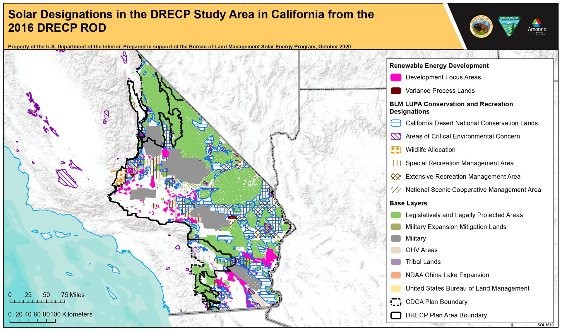
This “smart-from-the-start” management directive was finalized in early 2016 for 22.5 million acres of public and private land across seven Southern California counties, with the BLM managing 10.8 million acres of public land. Of this, 388,000 acres were pre-screened for renewable energy “development focus areas,” 4.2 million acres were designated as conservation lands, and 3.5 million acres were reserved for recreation. Additionally, 440,000 acres of variance and “general public lands” (previously unallocated public lands) could potentially be available for future development, requiring an extensive application process. The 2016 DCREP was based on the projected 20,000 MWh of electricity the state anticipated needing by 2040. However, it did not account for the substantial energy demands of the current datacenter-AI-crypto boom.[5]
After Donald Trump’s election in November 2016, his administration immediately placed roadblocks on the DRECP. Just before Trump left office in 2021, the Department of the Interior issued a revised proposal that significantly weakened the 2016 plan, reducing protections for 1.8 million acres of conservation lands while prioritizing “critical mineral” mining interests. Instead of 388,000 acres, more than 800,000 acres would also be allocated for renewable energy projects. However, once President Biden took office, the BLM under his administration rescinded the Trump administration’s proposed changes to the DCREP in December 2022. With the Biden administration’s 2022 Inflation Reduction Act (IRA), applications to lease and permit utility-scale solar projects increased dramatically, especially on federal lands. However, with Trump’s 2024 election, his Project 2025–driven administration reversed course and labeled solar and wind energy an enemy of the nation’s economic agenda, stalling climate action just as renewable power was beginning to reshape the American landscape. Consequently, some of the Biden-supported IRA-funded projects are now on hold or will not be developed.
Nevertheless, the Trump administration’s efforts to halt renewable energy growth will ultimately fail. Even after the administration ends its phase-out of the Biden clean energy tax credits at the end of 2025, electricity generated by solar and wind without subsidies will remain cheaper than the least expensive fossil fuel source.[6] In contrast, according to Oil Change International, U.S. fossil fuel companies receive nearly $31 billion annually in subsidies to support their polluting and carbon-emitting industry.[7]
In 2024, solar accounted for 32 percent of California’s electricity—including a 13 percent contribution from small-scale distributed solar—while natural gas generated 35 percent, according to the EIA.[8] However, during the twelve months ending in April 2025, solar surpassed natural gas as the state’s leading source of electricity.[9]
Kern County leads California in annual net electricity production, generating 34.5 TWh, according to GridInfo.[10]. Wind and solar together account for 61 percent of this output, with natural gas contributing 37 percent.[11] Within the county, the western Mojave’s Fremont Valley produces the largest share—18.7 TWh from combined wind and solar alone. To the south, solar farms across the Antelope Valley in Los Angeles County generate an additional 3.1 TWh annually, making the western Mojave Desert the state’s most productive region for solar energy.[12] Much of this electricity is generated close to the population centers it serves, reducing transmission losses and strengthening grid reliability.
Additionally, the western Mojave boasts the highest concentration of ground-mounted PV solar installations in the U.S. When comparing fossil fuel-generated electricity to solar, consider that Kern County’s largest natural gas power plant, the 750 MW Pastoria Energy Facility at the Edmonston Pumping Plant[13], produces 4 TWh of electricity annually on just 31 acres. However, according to the EPA, it emits 3.3 million metric tons of CO2 each year, while PV solar arrays of any scale result in nearly net-zero greenhouse emissions.
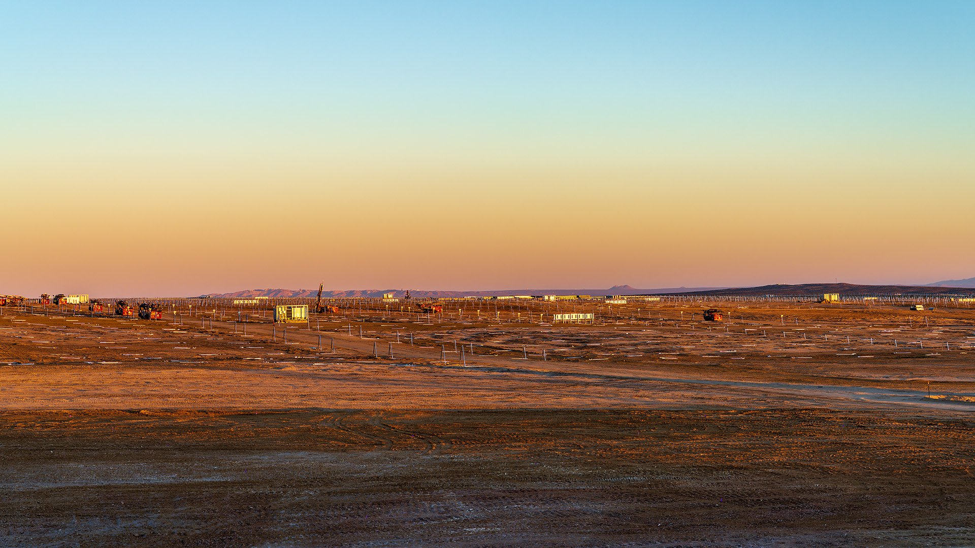
A rapid expansion of the renewable energy footprint is taking place in southern Fremont Valley, primarily on privately held land. Descending eastward along State Route 58 from the Tehachapi Mountains, the scale of this buildout becomes unmistakable: miles of operational and under-construction solar fields blanket the desert floor, while wind turbines line the foothills. Among them is the 1.5 GW Alta Wind Energy Center, currently the third-largest onshore wind farm in the world, which supplies power to Southern California Edison. Adjacent stands the historic Tehachapi Pass Wind Farm, the nation’s first large-scale wind energy project, built in the 1970s and 1980s, linking decades of renewable development to today’s vast industrial energy landscape.
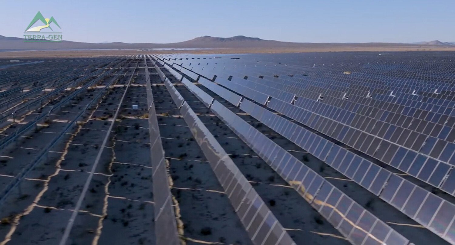
As of November 2025, the largest operational utility-scale solar farm in Fremont Valley is the 4,600-acre, 875 MW Edwards Sanborn Solar + Energy Storage Project, a public–private partnership between the U.S. Department of Defense and Terra-Gen, LLC. Located partly within Edwards Air Force Base on 2,546 acres, the project integrates 1.9 million photovoltaic panels and 3.3 gigawatt-hours (GWh) of battery storage to produce roughly 1.7 TWh of electricity annually.
The second-largest installation, Solar Star I & II, occupies 3,200 acres near Rosamond at the Kern–Los Angeles County line. Comprising 1.7 million panels with a capacity of 776 MW, it generates approximately 1.6 TWh per year. Nearby, the 230 MW Antelope Valley Solar Ranch, covering 2,100 acres of retired farmland near Lancaster, has been operational since 2014 and produces around 569 GWh annually.[14]
Several of the most expansive solar developments in Kern’s Fremont Valley are now advancing through county and state permitting. Terra-Gen’s 1.4 GW Discovery Solar PV and Storage Project would cover up to 7,700 acres southwest of the town of Mojave. Even larger, AES’s proposed 1.5 GW Bellefield Solar + Storage Project would extend across as much as 8,371 acres in unincorporated Kern County and California City. Once built, Bellefield is expected to become California’s largest solar farm.[15] AES has already secured a 15-year power purchase agreement with Amazon Web Services—powering only a fraction of AWS’s 259 global data centers.
Adjacent to Kern is San Bernardino County, the largest in the nation at 20,105 square miles. Nearly half of this terrain—about 9,000 square miles—is mixed-use federal land managed by the Bureau of Land Management (BLM).[16] The Mojave Trails National Monument, Mojave National Preserve, Joshua Tree National Park, and other federally protected wilderness areas are also within its borders. It is home to three military installations, including Fort Irwin National Training Center, China Lake Naval Air Weapons Station, and Marine Corps Air Ground Combat Center Twentynine Palms, collectively covering over 4,000 square miles. Although it supports fewer solar farms than Kern County, San Bernardino County was the first in the nation to host utility-scale solar farms, built in response to the 1973 energy crisis. As of November 2025, 14,500 acres, or nearly 23 square miles of San Bernardino County’s Mojave region, have utility-solar installations.
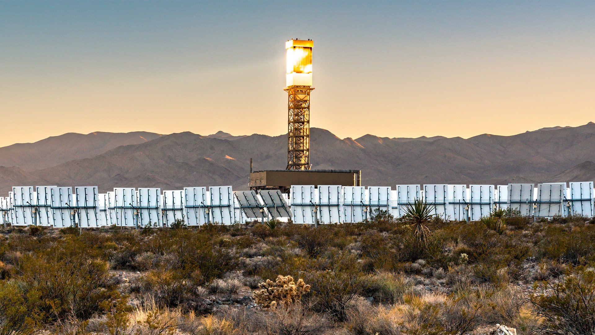
The county’s largest utility-scale solar farms are Solar Energy Generating Systems (SEGS), also known as concentrated solar thermal plants. Unlike photovoltaic (PV) systems, which use solar cells to directly convert sunlight into electricity, SEGS harnesses solar energy by focusing sunlight with mirrors or lenses onto a receiver. This receiver may take the form of a tube containing a heat-transfer fluid mounted within a mirrored parabolic trough, or a central tower surrounded by a vast field of mirrors. In both designs, sunlight is converted into heat through a thermochemical process, using synthetic oil, water, or molten salt to drive a steam turbine generator. SEGS can also store energy for use after sunset or during cloudy periods. Both systems typically rely on natural gas to initiate operations.
Using parabolic trough technology, SEGS I-IX, built between 1984 and 1990 and located 40 miles apart in Daggett, Kramer Junction, and Harper Lake, could at peak produce 354 MW daily. Operational in 1984, the Daggett plant (SEGS I & II) was the first large-scale commercial solar facility in the U.S. These power plants were the only sources of solar power in the country for nearly twenty years. The only remaining operational SEGS plant is SEGS IX at Harper Lake.
The land where SEGS I & II once stood is now part of Clearway’s 482 MW PV Daggett Solar and Energy Storage project, which extends into nearby retired farmland. The adjacent Coolwater Generating Station, a retired coal and gas-fired power plant, allows the reuse of existing energy infrastructure and transmission lines. The solar plant includes a 394 MW battery storage facility and became operational in 2023.
Daggett, located just southeast of Barstow, was also the site of Solar One and Solar Two, experimental pilot concentrated solar thermal plants that used the solar power tower design. The Department of Energy built Solar One to test this technology on a larger scale. Completed in 1981, Solar One generated 7 MW with 1,818 mirrors or heliostats and remained operational until 1986. Solar Two was converted from Solar One in 1995 by adding more heliostats and switching from an oil-based thermal fluid to molten salt, which allowed it to produce 10 MW. Solar Two operated for four years and was demolished ten years after decommissioning.
In 2019, responding to public concerns, the San Bernardino County Board of Supervisors voted to prohibit solar farms and other utility-scale renewable energy projects on one million acres of private land in rural living districts—specifically for operations that sell more than 50 percent of their electricity to the grid for use elsewhere. The Renewable Energy Conservation Element 4.10 does not apply to projects on BLM-managed public land within the county and does not affect community solar initiatives that generate electricity where it is consumed. However, several projects may still move forward because they were filed and accepted before the moratorium took effect. One example is the proposed 500 MW Sienna Solar Center, which could cover 1,932 acres of dry lakebed and retired farmland in Lucerne Valley, east of Victorville.
Ivanpah Solar Electric Generating System (ISEGS), Ivanpah, CA, 2022. Photo: Kim Stringfellow.
The 3,445-acre Ivanpah Solar Electric Generating System (ISEGS) lies just north of Interstate 15 on the California-Nevada border, adjacent to the 300 MW Stateline Solar PV array, spanning 640 acres. Once the world’s largest concentrated solar thermal plant, ISEG is San Bernardino County’s most visible and disputed experiment in utility-scale renewable energy development.
The facility’s 352,000 computer-controlled heliostats concentrate sunlight onto three 459-foot-tall boiler towers, which drive steam turbines to generate electricity. The vast geometric heliostat field is discernible from space, and the towers themselves, when operating, appear from the air like glowing white-hot monoliths—three otherworldly “terrestrial suns.” Both commercial airplane pilots above and drivers traveling on the interstate have reported being momentarily blinded by the towers’ intense glare. In many ways, ISEGS is like Solar One and Solar Two, amplified on a massive scale.[17]
Built before the DCREP was enacted, ISEGS has been controversial from the start as a technical, economic, and environmental failure acknowledged by both conservative politicians and progressive environmentalists. Its lifespan is short: the plant is set to shut down in 2026, just eleven years after it began operations—thirteen years before its planned decommissioning—following the early termination of its power purchase agreement with Pacific Gas and Electric (PG&E), announced in early 2025.[18]
Six months after the $2.2 billion facility opened, in February 2014, the California Energy Commission reported that it was generating only half of its expected annual energy output. The reason: less sunlight due to cloud cover, overcast skies and even jet contrails, which the system’s owners—NRG Energy Inc., Google Inc., and Brightsource Energy—had not anticipated. Proper alignment with the sun and keeping the heliostats free of desert dust also caused operational problems, contributing to its underperformance.
Additionally, the technology developed by BrightSource Energy was far from carbon-neutral—it must burn natural gas to heat the system and serve as a supplemental fuel source. The amount required is excessive for a supposedly renewable energy source. When the plant first came online, it burned 254 GWh of natural gas, producing 46,084 metric tons of CO2 for 419 GWh of electricity—about half of its advertised capacity.[19] California requires that conventional power plants that exceed 25,000 metric tons per year participate in cap-and-trade programs. Environmental critics argued that, as a “hybrid” power plant, Ivanpah should not have qualified for federal funding and tax breaks as a “green” energy project.
But even more damaging are ISEGS’s permanent environmental impacts—the project was built on pristine, intact desert woodland south of the Mojave National Preserve’s Clark Mountain Range, which is considered prime habitat for the critically endangered desert tortoise (Gopherus agassizii) and other rare plant and animal species.
The desert tortoise is a long-lived species, living up to 50 to 80 years. Like humans, it reaches sexual maturity by its teens, so it reproduces far more slowly than other reptiles. For up to 9 months, during late fall and winter, desert tortoises enter a state of dormancy called brumation in underground burrows and become active above ground from June to October, especially during the late summer monsoon season.
Due to the species’ federal conservation status—90 percent of Mojave desert tortoises have disappeared since 1984—BrightSource Energy needed to work with federal and state wildlife officials to conduct tortoise population counts before starting construction. When biologists hired as consultants (acting as impartial intermediaries between the solar company and wildlife agencies) found more than twice the expected number of tortoises on the site, construction was immediately halted to evaluate and develop an effective tortoise translocation plan as required by California’s Endangered Species Act.
Kelly Herbinson, executive director of the Mojave Desert Land Trust (MDLT), was one of the biologists hired who eventually oversaw the ISEGS translocation. Herbison started working for an environmental consulting firm specializing in desert tortoises in 2002. She was hired as an ISEGS consultant in May 2011 and served as one of the designated lead biologists until construction began at the end of 2013.
Her team of biologists found more than 50 adult tortoises and their burrows at the ISEGS construction site. The initial survey had identified only sixteen tortoises. The captured tortoises were temporarily relocated to a nearby facility and carefully monitored for an entire year before being released. Tortoises living in the nearby “recipient area” or release site were also monitored, as were a control group of tortoises. This comprehensive environmental monitoring lasted for ten years and, not surprisingly, was expensive—Herbison estimates it cost ISEGS’ owners about $1 million per tortoise, or more than $50 million in total.
Herbinson participated in six or seven more large-scale desert tortoise translocations at different sites in California and Nevada deserts after the ISEGS project. She remembers that ISEGS was the most successful effort she was involved in, mainly because the company provided every resource her team asked for. The biologists’ later report found no significant difference in mortality rates between translocated tortoises and the control group and noted that the resident population adapted well to the newcomers. According to the November 2017 report, annual survival rates ranged from 89 to 100 percent, with older tortoises demonstrating the greatest resilience.[20] However, Herbinson emphasizes that ISEGS permanently fragmented the species’ habitat—damage that will continue to undermine its genetic diversity. She also points out that the construction of Interstate 15 had already disrupted habitat connectivity for tortoises and other desert wildlife long before the solar facility was built.
Reflecting on the news that ISEGS was shutting down operations, Herbinson states, “All that work, all that money, all that destruction, for what?” She is proud of her work at ISEGS but now feels that funds would have been better spent protecting the species and its habitat elsewhere: “If someone gave me, now as executive director of MDLT—$50 million, I could pretty much protect the whole desert. I could keep it a completely interconnected, thriving ecosystem. That’s what I grapple with.”
Although the ISEGS tortoise translocation was considered a success, fatalities among birds, bats, and insects soared within a 260-meter radius of the solar towers once the plant became operational in 2014. Situated along the Pacific Flyway, in one of the planet’s recognized biodiversity hotspots, ISEGS occupies a critical ecological corridor. Across North America, bird populations have already declined by nearly three billion individuals in less than 50 years,[21] mainly due to human activity. So, when reports surfaced that Ivanpah’s glaring, science-fiction-like towers were incinerating wildlife mid-flight, environmental and conservation groups reacted swiftly—and loudly.
All renewable energy technologies can harm or kill wildlife in various ways. Many incidents occur when birds and raptors collide with spinning wind turbine blades or the highly reflective surfaces of PV panels and parabolic troughs. Animals can also become trapped by fencing, making them vulnerable to predators. Solar energy systems like ISEGS pose a unique risk—death by incineration—when unfortunate flying creatures fall victim to “solar flux,” a phenomenon that creates a radial heat field, with temperatures near the concentrating tower reaching up to 900° F.
ISEGS employees called these frequent incidents “streamers” because of the fleeting smoke trails produced when insects, birds, or bats were singed or charred in mid-flight, often resulting in their death. A disturbing October 2013 report from the U.S. Fish and Wildlife National Fish and Wildlife Forensics Laboratory revealed that carcasses of a diverse variety of passerine and resident bird species—totaling 49—were found at ISEGS before or at the site during the USFWS visit on October 21–24, 2013. It also noted that USFWS Office of Law Enforcement (OLE) staff witnessed, on average, one streamer event every two minutes over the four days they conducted the study at Ivanpah.[22]
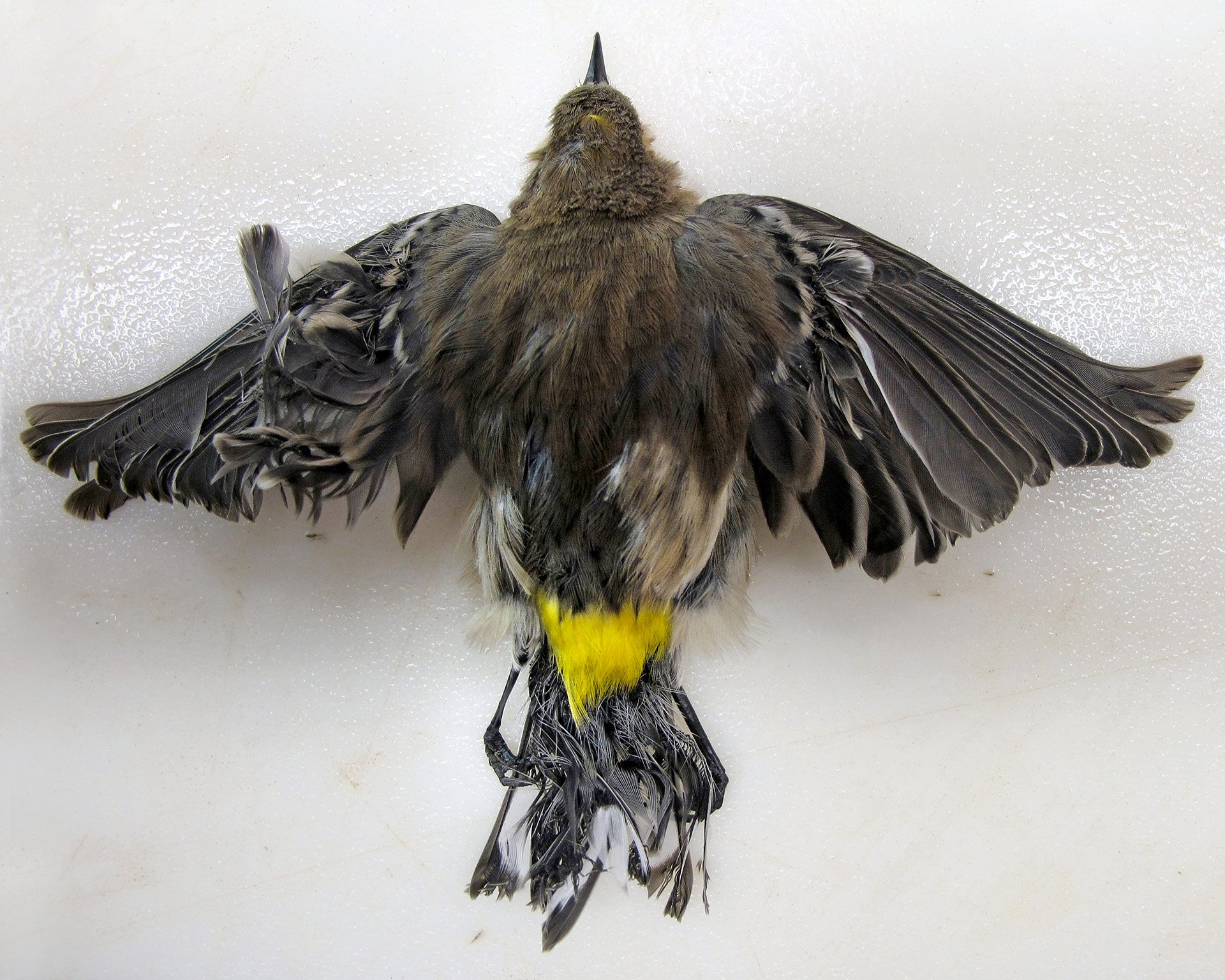
A yellow-rumped warbler (Setophaga coronata) burned mid-air at ISEGS, U.S. Fish and Wildlife Service, 2013.
Of the 141 carcasses collected, 47 were determined to be victims of solar flux, including those protected under the Migratory Bird Treaty Act. These included the colorful, insect-eating yellow-rumped warbler (Setophaga coronata) and one of its predators, the peregrine falcon (Falco peregrinus), which may have been the species observed by USFWS forensic staff. The report noted, “a falcon or falcon-like bird with a plume of smoke arising from the tail as it passed through the flux field. Immediately after encountering the flux, the bird exhibited a controlled loss of stability and altitude but was able to cross the perimeter fence before landing. The bird could not be further located following a brief search….”
The bird-carcass count was limited to the facility’s property and did not include those found outside the fenceline, where some birds may have escaped death in the solar flux field but were seriously injured. The report did not consider predation or scavenging of injured or dead birds, so the actual number was likely much higher. Additionally, the report was created before ISEGS was fully operational, and the mortality counts were recorded when the facility was running at 33 percent capacity.
The OLE staff also observed a large number of dead insects during their site visit, including migratory dragonflies and monarch butterflies (Danaus plexippus). Butterfly carcasses amounted to thousands. It was later speculated that the solar flux field creates an insect-attracting light around the tower, brighter than daylight, forming a “mega-trap” that lures insects to the towers. Insect-eating bird species such as flycatchers, swallows, swifts, and warblers try to feed, which in turn brings predatory raptors into the area, making the “entire food chain vulnerable to injury and death.”
ISEGS hired the environmental consulting firm H.T. Harvey and Associates to conduct avian monitoring for one year, starting in October 2013. Specially trained dogs were used to track and retrieve bird carcasses. This count yielded 695 dead birds from 83 species, plus 32 dead bats. After accounting for missing carcasses using scientific methods, the biologists estimated that approximately 3,504 birds die annually at the Ivanpah site. This estimate includes 774 birds killed in collisions with heliostats or other site infrastructure, as well as 707 birds directly killed by solar flux. The remaining 2,012 “succumbed to unknown causes.”[23] News sources, including the Los Angeles Times, published statistics citing that ISEGS was responsible for more than 6,000 deaths annually.[24]
Ultimately, CAFWS biologists determined that ISEGS’s annual avian mortality rate was “low” relative to local, regional, and national populations. Their assessment was statistical: when compared with the billions of birds killed annually in the United States by building collisions, vehicle strikes, and predation by domestic cats, the estimated few thousand deaths at Ivanpah were deemed negligible.[25] Yet such reasoning exposes a central paradox in the transition to renewable energy. While the cumulative toll may appear small in statistical terms, the losses at sites like ISEGS reveal the ecological costs of large-scale energy infrastructure—even when built in the name of sustainability. The question, then, is not simply how much energy can be generated without carbon, but how renewable energy can be developed without replicating the ecological disruption that defined the fossil-fuel era.
Once completed, the 600 MW Enterprise Solar Storage Project’s photovoltaic panels will span 2,320 acres east of Mojave, CA. Photo: Kim Stringfellow.
As hedge funds, private equity firms, and multinational energy corporations rushed to lease or purchase land across the desert, they sought to capitalize on Biden-era Inflation Reduction Act (IRA) subsidies and tax incentives for renewable energy, electric vehicles, rooftop solar, and critical mineral extraction. But as industrial-scale solar developments began encroaching on the edges of rural desert towns, local residents began to take notice—and many were far from pleased with their new industrial neighbors.
Most rural communities in the Mojave lean politically conservative, and many welcomed “Trump 2.0’s” rollback of the $783 billion IRA—a sweeping program the new administration dismantled within months of taking office in 2025. Some IRA-backed renewable energy projects have since been paused, while others face cancellation. Under the direction of Trump-appointed Interior Secretary Doug Burgum, all solar and wind projects on public land now require direct federal approval.[26]
The effects are already visible. In October 2025, the Department of the Interior canceled the massive 6.2 GW Esmeralda Seven Solar Project in west-central Nevada, signaling what many see as the beginning of a broader “renewable energy purge.” Additional projects on public lands—some with existing power purchase agreements but suddenly without federal funding—may struggle to attract the private capital needed to move forward.
Still, not all development has stopped. Projects that have cleared permitting and are already under construction, or those located on private land, continue to advance. One of the most contentious is the 530 MW Aratina Solar Center, near the working-class desert communities of Boron and Desert Lake in eastern Kern County, California. The project, owned by Avantus LLC, a global private equity firm, is being built within sight of the long-operating Rio Tinto Borax Mine. The power it will generate won’t serve the surrounding community—it will be transmitted elsewhere. Aratina has faced intense local opposition.
From the outset, the unpopular Aratina project faced strong opposition from residents, environmentalists, and regional news outlets. Concerns arose because the privately owned parcels—spanning 2,317 acres where Avantus planned the development—contained an intact old-growth western Joshua tree (Yucca brevifolia) woodland, with approximately 4,700 trees. About 500 of these trees were surveyed, all at least 16 feet tall and possibly up to 200 years old. Avantus would not transplant those trees; instead, it was required to pay a mitigation fee of $10,521.95 per acre, totaling $1.3 million, to comply with the climate-driven 2023 Western Joshua Tree Conservation Act. The law “prohibits the importation, export, take, possession, purchase, or sale of any western Joshua tree in California unless authorized by the California Department of Fish and Wildlife (CDFW).” Developers must obtain permits from CDFW for the incidental take (removal) of Joshua trees and pay a mitigation fee based on each tree’s location and height. Fees are deposited in the Western Joshua Tree Conservation Fund. Central California’s NPR-affiliate, KVPR, reporting in April 2025, found that the solar industry spent upwards of $2 million lobbying to influence a favorable outcome during the legislation process.
In addition, Avantus voluntarily purchased grazing rights on 215,000 acres of public land—including roughly 80,000 acres of western Joshua tree woodland that will remain undeveloped—through the Onyx Conservation Project, located between Ridgecrest and Mojave, California. Separately, the company must pay to relocate any desert tortoises or Mohave ground squirrels (Xerospermophilus mohavensis) found on the parcels.
Despite these measures, local residents and Joshua tree enthusiasts were alarmed by videos and photos showing Avantus workers shredding hundreds of old-growth, downed Joshua trees on site. Outsiders might dismiss the opposition in Boron and Desert Lake as NIMBYism, but residents had deeper concerns—chief among them a serious public health risk from the soil disturbed during construction.
Coccidioidomycosis, or “cocci,” commonly known as valley fever, is caused by a naturally occurring fungus endemic to California’s Central Valley, the western Mojave Desert, and other arid regions of the American Southwest. Infection occurs when cocci spores are released into the air through soil disturbance and inhaled. While symptoms can be mild, valley fever can also cause severe, lifelong illness or even death, and it is frequently underdiagnosed. Livestock and other animals are also susceptible. The Centers for Disease Control (CDC) has labeled cocci a “silent epidemic,” infecting more than 206,000 people in the U.S. each year, with documented cases rising—partly due to increased awareness.[27]
Farm workers, particularly those working close to the ground, are historically the most exposed population. Studies show solar farm workers face similar risks: a 2018 CDC study of 2,410 solar employees in southeastern Monterey County documented nine cases of cocci, translating to an incidence rate of 1,095 cases per 100,000 annually—between 4.4 and 210.6 times higher than background county rates.
In 2024, the Los Angeles Times reported that a group of concerned residents, with guidance from valley fever expert Dr. Antje Lauer, collected soil samples from five Aratina parcels under development. All tested positive for coccidioidomycosis. Making these findings public prompted Avantus to extend the boundaries of the solar farm facing the towns by up to half a mile. [28]
The Aratina Solar Center highlights the tensions surrounding large-scale renewable energy in the Mojave Desert. While developers cite climate goals and mitigation measures, local communities face ecological loss and public health risks, plus the energy generated primarily flows elsewhere. From shredded old-growth Joshua trees to disturbed soil potentially laced with valley fever, the controversy highlights a broader question: how can the push for carbon-free energy balance the needs of ecosystems, human health, and the people who live closest to these sprawling solar developments?
The expansion of utility-scale solar across California’s Mojave Desert reveals a stark paradox: the urgency to reduce carbon emissions can result in negative impacts on fragile ecosystems, endangered species, and the desires of rural communities. Projects like ISEGS and Aratina demonstrate that even well-intentioned renewable energy can bring ecological disruption, public health risks, and local opposition when sited without careful planning or community input. Policy shifts—from the Biden-era IRA incentives to the 2025 Trump rollbacks—have only amplified uncertainty. As this dispatch series continues, we will explore the challenge ahead: finding pathways—through distributed generation, conservation-minded siting, and stronger public engagement—that can deliver carbon-free power while preserving the Mojave’s unique ecological and cultural landscapes.
Aerial photography of ISEGS by Gilles Mingasson reproduced with permission. © Gilles Mingasson 2014 -2025.
Did you enjoy reading this dispatch? Support us with your tax-deductible donation.
FOOTNOTES (click to open/close)
[1] Other renewables include bioenergy, geothermal, tide, and wave energy. Ember, Global Electricity Review 2025: Executive Summary (April 8, 2025), https://www.ember-energy.org/latest-insights/global-electricity-review-2025/.
[2] John Fitzgerald Weaver, “Solar Surpasses 10% of U.S. Electrical Generation for a Full Month for the First Time,” pv magazine USA, July 1, 2025, https://www.pv-magazine-usa.com/2025/07/01/solar-surpasses-10-of-u-s-electrical-generation-for-a-full-month-for-the-first-time/
[3] International Energy Agency (IEA), Electricity 2024 – Executive Summary (Paris: IEA, 2024), https://www.iea.org/reports/electricity-2024/executive-summary.
[4] Martin C. Offutt and Ling Zhu, Data Centers and Their Energy Consumption: Frequently Asked Questions, CRS Report No. R48646 (Library of Congress, August 26, 2025), https://www.congress.gov/crs_external_products/R/HTML/R48646.html.
[5] MWh (megawatt-hour) is a unit of energy produced or consumed in one hour. “Nameplate capacity” indicates the maximum power output a plant can achieve under ideal or peak conditions.
[6] The Biden-era clean energy tax credits provided 30 percent of installation costs for everything from utility-scale to smaller residential rooftop solar. Ryan Kennedy, “Solar Cost of Electricity Beats Lowest Cost Fossil Fuel – Even Without Tax Credits,” pv magazine USA, July 1, 2025, https://www.pv-magazine-usa.com/2025/07/01/solar-cost-of-electricity-beats-lowest-cost-fossil-fuel-even-without-tax-credits/
[7] Oil Change International, “Fossil Fuel Subsidies,” accessed November 2, 2025, https://www.oilchange.org/fossil‑fuel‑subsidies/.
[8] Small-scale solar is 20 MW or less. U.S. Energy Information Administration, California State Energy Profile — Overview (2024), https://www.eia.gov/state/print.php.
[9] John Fitzgerald Weaver, “Solar Becomes Top Source of Electricity in California,” PV magazine USA, July 9, 2025, https://www.pv-magazine-usa.com/2025/07/09/solar-becomes-top-source-of-electricity-in-california/.
[10] Data based 12 months from July 2025. GridInfo.com, “Kern County, CA – Summary of Electricity Activity in Kern County, CA,” accessed August 2025, https://www.gridinfo.com/california/kern-county.
[11] This sum was determined by adding up electricity generated eastern Kern County towns as listed on GridInfo.com (see above link). No natural gas power plants were included.
[12] This sum was determined by adding up electricity generated north Los Angeles County towns as listed on GridInfo.com (see above link). No natural gas power plants were included.
[13] The State Water Project (SWP) is California’s largest single electricity consumer. While the Pastoria Natural Gas Power Plant generates 750 MW, the SWP’s pumping operations can consume up to 787 MW.
[14] Rising water costs and climate change have made farming in the Antelope Valley largely unprofitable, leading some landowners to sell or lease their property to solar developers. Farr notes that 14 Los Angeles County solar projects now occupy retired farmland. Irena Farr, Opportunities for Agriculture and Solar in the Urban Fringe: The Antelope Valley as a Case Study (Los Angeles: UCLA, The Ralph and Goldy Lewis Center for Regional Policy Studies, 2021), https://escholarship.org/uc/item/5dm8c72n.
[15] California Governor’s Office of Planning and Research, California Environmental Quality Act (CEQA) e-Notice, Discovery Solar PV and Storage Project (Terra-Gen Solar), Kern County Lead Agency, SCH No. 2025071048, July 24 2025, https://ceqanet.lci.ca.gov/2025071048 and California State Clearinghouse, “SCH Number 2021010168 – Bellefield Solar Project by 50LW 8ME (8Minute Energy): Response to Comments,” https://ceqanet.lci.ca.gov/Project/2021010168. Both projects will be built on private land.
[16] BLM manages about 5,802,290 acres in San Bernardino County. Jonathan Hume, “Senate Floats Auction of 1000s of Acres of Morongo Basin Public Land,” The Desert Trumpet, June 18, 2025, https://www.deserttrumpet.org/p/senate-floats-auction-of-1000s-o.
[17] Todd Woody, “Pilots complain that glare from the world’s biggest solar power plant is blinding them,” Quartz, June 11 2014, https://qz.com/188109/pilots-complain-that-glare-from-ivanpah-the-worlds-biggest-solar-power-plant-is-blinding-them.
[18] NRG Energy, “NRG Update on Ivanpah Solar Power Plant,” January 17, 2025, https://www.nrg.com/insights/sustainability/nrg-update-on-ivanpah-ppa-buyout.html.
[19] “Ivanpah Solar Power Facility,” Wikipedia, last modified October 21, 2025, https://en.wikipedia.org/wiki/Ivanpah_Solar_Power_Facility.
[20] Brett G. Dickson et al., Process- and Scale-based Determinants of Survival for Translocated Mojave Desert Tortoises in the Ivanpah Valley, California; April 2011 through May 2017 (Truckee, CA: Conservation Science Partners, November 29, 2017), https://www.csp-inc.org/public/CSP_ISEGS_Tortoise_Report_5yr_FINAL.pdf.
[21] Gustave Axelson, “Vanishing: More Than 1 in 4 Birds Has Disappeared in the Last 50 Years,” Cornell Lab of Ornithology, September 19 2019, https://www.allaboutbirds.org/news/vanishing-1-in-4-birds-gone/.
[22] Rebecca A. Kagan et al., Avian Mortality at Solar Energy Facilities in Southern California: A Preliminary Analysis (National Fish and Wildlife Forensics Laboratory, 2014), https://www.ourenergypolicy.org/wp-content/uploads/2014/04/avian-mortality.pdf.
[23] Peter Fairley, “Solar Towers Don’t Seem to Be the Bird Destroyers Once Thought,” IEEE Spectrum, November 2, 2015, https://spectrum.ieee.org/reassessing-bird-deaths-from-solar-power-towers.
[24] Louis Sahagun, “This Mojave Desert Solar Plant Kills 6,000 Birds a Year. Here’s Why That Won’t Change Any Time Soon,” Los Angeles Times, September 2, 2016, https://www.latimes.com/local/california/la-me-solar-bird-deaths-20160831-snap-story.html.
[25] American Bird Conservancy, “New Study Confirms Building Collisions Kill Over One Billion Birds Annually in U.S.,” August 7, 2024, https://www.abcbirds.org/news/bird-building-collisions-study-2024/
[26] Maxine Joselow, “Groups Sue E.P.A. Over Canceled $7 Billion for Solar Energy,” New York Times, October 6, 2025. https://www.nytimes.com/2025/10/06/climate/epa-solar-for-all-lawsuit.html.
[27] Centers for Disease Control and Prevention (CDC), “Valley Fever (Coccidioidomycosis),” updated April 24 2024, https://www.cdc.gov/valley-fever/index.html
[28] Avantus Power LLC, “Site Map,” Aratina Solar Center website, accessed November 2, 2025, https://www.aratinasolar.com/site‑map.