No force is reshaping the Mojave Desert more rapidly than utility-scale solar development. The hotbed of this buildout is Nevada, one of the most resource-exhausted and weakly regulated states in the nation. With roughly 80 percent of its land, or about 56.3 million acres, under federal ownership, Nevada has long been a haven for extractive industry: it leads the nation in gold production and lithium mining, industries built on subsidized access to public land.
Utility-scale solar has been sold to the public nationwide as a clean path to decarbonization. Yet the vast stretches of the Mojave Desert being sacrificed for this buildout will increasingly serve the tech industry’s expanding network of data centers, whose insatiable demand for electricity to power AI, cloud computing, and crypto mining appears to be the true engine of Nevada’s solar boom—not decarbonization for the public good. What follows is an inventory of that boom: what is being built, who is building it, where, who profits, and who pays the price.
The Nevada portion of the Mojave extends from Laughlin, in Clark County at the state’s southern tip, northwest along the Nevada–California border from Primm into Nye and Esmeralda counties, where the Mojave transitions into the Great Basin, and eastward across the shimmering Las Vegas Valley, to the Nevada–Utah border.
Southern Nevada’s Clark County, home to Las Vegas, is the center of the state’s industrial solar growth due to the region’s high solar radiation potential and vast public-land availability. The county generates 11.3 terawatt-hours (TWh) of solar electricity each year, making up 35 percent of its annual energy supply. In 2024, solar generated from utility- and small-scale sources accounted for 31 percent of total electricity generation.[1]
Utility-scale solar power plants in the county include the 300 megawatt (MW) Silver State North and South photovoltaic (PV) projects, located at the California/Nevada border in Primm, Nevada, opposite the controversial and still-operating Ivanpah Solar Electric Generating System (ISEGS). The Silver State solar fields surround the 530 MW natural gas-fired Higgins Generating Station.
Farther northeast, acres of desert in the scenic and largely undeveloped Eldorado Valley, south of greater Las Vegas along U.S. Route 95, are now covered with large utility-scale PV solar farms. These include the 802 MW Copper Mountain Solar Facility situated on 4,000 acres south of Boulder City. Other co-located solar projects include the 150 MW Boulder Solar, the 400 MW Techren Solar (both PV), and the 64 MW Nevada One parabolic trough concentrated solar power plant. Collectively, the plants’ capacity exceeds one gigawatt (GW). Just north, the 180 MW Townsite Solar Project Hybrid is located next to Boulder City’s airport. These installations share fence lines with the 87,310-acre Boulder City Conservation Easement (BCCE) established in 1995. The BCCE, managed by the Clark County Desert Conservation Program, is a protected habitat corridor for desert tortoises (Gopherus agassizii) and another 232 sensitive species. It also serves as a mitigation reserve for translocated tortoises resulting from private land development in previously undeveloped desert areas within the county.
Some 15 miles northeast of Las Vegas along Interstate 15 is Dry Lake, a long-standing industrial corridor now known as the Dry Lake Energy Zone. A Bureau of Land Management (BLM)-managed 3,975-acre section of public land hosts the 235 MW Playa Solar Project, the 200 MW Dry Lake Solar Energy Center, MGM’s 100 MW Mega Solar Array (also called Harry Allen Solar Energy), and several smaller PV farms. All are situated near the older natural-gas-fired 628 MW Harry Allen Generating Station, which connects to the existing One Nevada Transmission Line and will eventually link with the Greenlink West Transmission Project, which then connects to northern Nevada via the east-west Greenlink North.

The largest cluster of utility-scale solar farms in Nevada’s Clark County is located in the Dry Lake Energy Zone, 15 miles northeast of Las Vegas. From bottom left, counterclockwise: Playa Solar, MGM’s Mega Array (aka Harry Allen Solar Center), and Dry Lake Solar Energy Center. Just north of Dry Lake, on the Moapa Indian Reservation, are Arrow Canyon Solar Hybrid, Eagle Shadow Mountain Solar Farm, and the Moapa Southern Paiute Solar Project. South of Interstate 15 lies the Gemini Solar Project. At 5,000 acres, it is currently the largest PV solar farm in the U.S
Approximately five miles further north on Interstate 15, three PV solar farms have been built in collaboration with the Moapa Band of Paiutes and federal agencies. The 2,000-acre, 250MW Moapa Southern Paiute Solar Project was the first utility-scale solar development on tribal lands. It became operational in 2017. The Moapa worked closely with First Solar, Inc., and federal agencies to develop the project. Of the 650 hired, 150 were Native workers, including fifty Moapa tribal members. The Los Angeles Department of Water and Power (LADWP) has a multiyear power purchase agreement with tribal and private co-ownership, ensuring that the electricity generated here isn’t used locally.
Nevada generates more than three times as much solar electricity per person—4.3 MWh per person, compared with California’s 1.4 MWh.[2] Las Vegas also has more solar panels per person than any major U.S.
The commissioning of this renewable energy project marked a major victory for the Moapa. Tribal members had suffered serious health issues for years because of the nearby Reid Gardner 557 MW coal-fired power station just outside the reservation boundary. Operating for fifty years, it was considered the country’s dirtiest coal plant in 2007, emitting 341,000 tons of carbon dioxide annually. The plant also released 4,000 tons of nitrogen oxides, 1,200 tons of sulfur dioxide, and other harmful particulates each year until it was fully shut down in 2017. Its closure resulted from a 2013 lawsuit filed by the tribe and the Sierra Club against the state’s energy monopoly, NV Energy and the California Department of Water Resources. The plaintiffs received a $4.3 million settlement in 2015. The late Senator Harry Reid (D-NV), who was not related to the plant’s namesake, worked with the Moapa to pass legislation in 2013 mandating that investor-owned NV Energy shut down the coal-fired plant. A six-acre section of the former power plant has now been redeveloped into a 440 MWh lithium-ion battery storage array. The two other PV solar farms on the Moapa River Indian Reservation include the 300 MW Eagle Shadow Mountain Solar Farm on 2,300 acres, part of NV Energy’s portfolio, and the 275 MW Arrow Canyon Solar Hybrid project on 1,387 acres. Both became operational in 2023.
Nevada generates more than three times as much solar electricity per person—4.3 MWh per person, compared with California’s 1.4 MWh.[2] Las Vegas also has more solar panels per person than any major U.S. metro area outside of Hawaii.[3] Since 2016, the City of Las Vegas has powered all its municipal buildings with 100 percent renewable energy. The state’s mandated goal is to generate half of its electricity from renewable sources by 2030. NV Energy, a Berkshire Hathaway subsidiary, reported that 47 percent of electricity sold in 2024 came from renewables, suggesting Nevada is on track to meet that goal[4]—if current electricity generation and demand remain consistent.
In 2015, MGM Resorts International, Nevada’s largest private employer, completed an 8.3 MW array of 26,000 PV panels at its Mandalay Bay Convention Center on the Las Vegas Strip—at the time the largest rooftop solar array in the nation. In 2021, MGM’s 100 MW Mega Solar Array (a.k.a. Harry Allen Solar Energy) at Dry Lake went operational, providing 90 percent of the daytime power to its thirteen Las Vegas resorts.[5] Before construction began, over 110 households and two commercial landscapers participated in a BLM-managed native vegetation salvage effort at the site, gathering 643 cacti and yuccas.[6] Despite this, the entire 640 acres of undeveloped habitat was flattened and devoid of vegetation before construction began.
While Nevada has less stringent environmental laws to protect native plants, including the Joshua tree (Yucca brevifolia), which is now protected under the California Endangered Species Act, it is the first state to experiment with a more conservation-minded approach to traditional “blade and grade” construction at the 690 MW Gemini Solar Project, located thirty miles northwest of Las Vegas and just southeast of the Moapa Southern Paiute solar farms below I-15. Blading and grading destroy vegetation, compact soil, level ground, disrupt natural drainage, collapse animal burrows, and remove their food sources, leaving the site uninhabitable and barren except for a few invasive weed species. Fencing off the perimeter restricts or blocks wildlife travel or connectivity to migration corridors. Acres upon acres of solar panels create heat islands, increasing daytime shade and nighttime temperatures, which negatively affect guild species that rely on the same ecological resources within or nearby the solar farms.[7]
Covering 5,000 acres and featuring 1.8 million panels, Gemini is the largest PV solar farm in the U.S. and the eighth largest in the world. When operating at full capacity, Gemini’s solar array supplies approximately ten percent of Nevada’s peak electricity demand, supported by a 380 MW battery storage system.[8] The plant became operational in early 2024. The Moapa Band of Paiutes is one of four main partners and a partial landowner of the property.
The Gemini Solar Project was developed by Oakland-based Primergy Solar to minimize environmental impacts; however, this was not achieved voluntarily. Los Angeles Times energy writer Sammy Roth reported in 2023 that the BLM’s Las Vegas field office had conditionally approved the Gemini project after bureau staff considered halting it. Roth’s findings were based on a Freedom of Information Act (FOIA) inquiry by the Defenders of Wildlife, which revealed drafts of the final “record of decision” that would have denied Primergy’s permit due to potential harm to resident desert tortoise populations, interference with off-road vehicle recreation access, and disturbance of cultural resources, including the Old Spanish Trail.[9] A separate legal settlement filed by regional environmental groups required Primergy to adopt more environmentally friendly construction methods to protect tortoises and the three-corner milkvetch (Astragalus geyeri var. triquetrus), which is listed as critically endangered in Nevada and occurs exclusively in the southeastern part of the state and northwestern Arizona.
Legal prodding aside, Gemini is the only industrial-scale solar installation to date that hasn’t completely bulldozed and leveled the land before installing PV panels. Primergy left 44 percent of the perennial vegetation intact by “mowing” the native plants uniformly 18 to 24 inches tall by a “drive and crush” technique on alternate rows, which retains the plant’s root crown, theoretically allowing it to regrow. Machinery and vehicles were then restricted to these mowed rows to reduce disturbance and soil compaction. In the other alternate rows, the native vegetation was left intact. About 1,600 plants were also saved and used to recolonize the area after installation was completed, according to Roth.
Primergy then installed taller, multi-level PV panel support trusses adapted to the terrain’s natural contours, spaced wider than industry standards to minimize disturbance. Because the PV panels are bifacial, capturing energy from both sides, fewer array blocks were required. Raised fencing allowed tortoises and other small animals to pass underneath. Furthermore, the developers avoided building in natural drainages as much as possible, leaving the washes intact, and established two undisturbed north-south wildlife connectivity corridors between the three solar field sections. This resulted in a reduced footprint of under 5,000 acres; originally, Primergy planned to cover 7,038 acres.
Over time, as native vegetation regrows and the habitat stabilizes as projected, it is imperative to determine whether the tortoises, plants, and other guild species continue to tolerate, adapt to, and benefit from this heavily engineered habitat.
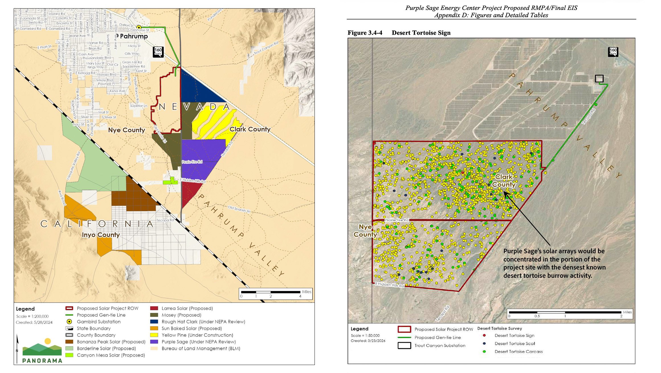
Before construction began in October 2021, 169 tortoises, including 130 adults, were surveyed and monitored for three years. When construction commenced, the tortoises presumed to have home ranges within the project area were removed and held in captivity for two years; those presumed to have home ranges adjacent to the project area were released safely outside the fenced construction zone. Both groups are part of a long-term monitoring study. After construction was complete in early April 2024, tortoise exclusion fencing was removed, captive tortoises were reintroduced along the solar field’s edge, and those living outside could now enter the field. According to a paper presented at the 2026 Desert Tortoise Council symposium, co-authored by Alice E. Karl, a community ecologist who has studied desert tortoises for nearly 50 years, 35 percent of the monitored tortoises were living within the solar field’s boundaries during 2025, with some successfully reproducing there.[10]
Over time, as native vegetation regrows and the habitat stabilizes as projected, it is imperative to determine whether the tortoises, plants, and other guild species continue to tolerate, adapt to, and benefit from this heavily engineered habitat. This is especially important because Gemini is the case study for programmatic design features and project guidelines established in the updated Western Solar Plan, which was approved in December 2024. Recommended conservation actions include retaining as much of the original undisturbed habitat and hydrology as the “maximum extent practicable” and “avoiding construction practices such as grading, disc and roll, and other techniques that disturb soil and completely remove vegetation.”[11] Such guidelines and others are certainly a step in the right direction, but the best outcome is for these enormous swaths of wilderness not to become renewable energy sacrificial zones in the first place.
Not all utility-scale solar projects proposed on public land have succeeded. The 850 MW Battle Born Solar Project, proposed in 2020, would have covered 9,180 acres—about fourteen square miles—almost twice the size of Gemini, on Mormon Mesa, northeast of Moapa Valley near Overton, Nevada. Much of Mormon Mesa is a designated Desert Tortoise Area of Critical Environmental Concern (ACEC). As a result of strong opposition from environmentalists, outdoor recreationists, and tribal and local residents, the BLM downgraded Battle Born’s application to “low priority.” When the international art community joined the fight because of Battle Born’s proximity to legendary land artist Michael Heizer’s Double Negative, a famous earthwork sculpture “carved” into the mesa with a bulldozer in 1969-70, the developers withdrew the project in July 2021.
South of Eldorado Valley’s solar energy zone, the threat of a 308 MW wind farm with 68 turbines on 9,154 acres led residents of Searchlight, Nevada, to join a coalition of regional tribal, environmental, conservation, and other residents from Bullhead City, Arizona, and Laughlin, Nevada. Together, they successfully advocated for the designation of the 506,814-acre Avi Kwa Ame National Monument in March 2023. Also known as Spirit Mountain, Avi Kwa Ame is a sacred cultural landscape; the Yuman speaking tribes, including the Mojave, Hualapai, Yavapai, Havasupai, Quechan, Maricopa, Pai Pai, Halchidhoma, Cocopah, and Kumeyaay regard it as the center of creation. The Hopi, Chemehuevi, Moapa Band of Paiutes, and the Las Vegas Paiute also see Avi Kwa Ame as an important spiritual, cultural, and ecological area to be protected and shared for future generations. The monument’s designation stands as a landmark victory—demonstrating that tribal nations, environmentalists, and local communities can unite across state lines to permanently protect sacred lands from industrial development.
 About 100 miles north of Avi Kwa Ame’s newly protected borders, the remote desert corridor stretching northwest from Pahrump Valley to Sarcobatus Flat along U.S. Route 95 now faces an onslaught of proposed utility-scale solar projects and transmission infrastructure threatening one of the Mojave’s last largely undisturbed “outback” landscapes. This stretch of highway is flanked by restricted military testing grounds—the Nevada National Security Site and Nellis Air Force Range. To the west lie the Funeral and Grapevine mountain ranges of Death Valley National Park. Beneath the entire area, a large carbonate-rock aquifer known as the Death Valley Regional Groundwater Flow System supplies “fossil water” to the Amargosa Valley, Ash Meadows, Devils Hole, Furnace Creek, and other remote desert springs and seeps.
The town of Pahrump, Nevada, with a population of 44,738, is situated between the Spring Mountains and California’s Nopah Range. It is a rural, conservative community where the nearest legal brothels can be reached from the Strip, about an hour’s drive away. Before Euro-American settlement in the late nineteenth century, the Nuwuvi, or Southern Paiute, called the valley Pah-Rimpi, meaning “Water Rock,” because of its once-abundant artesian wells. One part of the historic Old Spanish Trail runs through it, following earlier Indigenous trade routes of the region.
Just south of town, the Nye-Clark County line delineates the Pahrump Valley solar district, which encompasses eight major solar PV projects that are either proposed, approved, or now operational, covering more than 26,000 acres. These include Candela Renewables, LLC’s 400 MW, 2,433-acre Rough Hat Clark County Solar Project; Candela’s 400 MW, 2,400-acre Rough Hat Nye County Solar Project; Leeward Renewable Energy, LLC’s 700 MW, 4,414-acre Copper Rays Solar Project; Primergy’s 400 MW, 4,424-acre Purple Sage Energy Center; Clearway Energy Group, LLC’s 500 MW, 3,465-acre Mosey Solar Project; and two smaller solar farms totaling about 3,000 acres.
The problem for those of us inventorying renewable energy on public lands in the Desert West is that it is a game of whack-a-mole; applications appear, disappear, and reappear under a different company name.
And there’s more—west of the Nevada-California border, plans for three additional solar farms in Inyo County’s Charleston View area of Pahrump Valley existed until recently. These included 174 Global Power’s 500 MW Bonanza Peak Solar project, notably situated on up to 2,400 acres of private land just north of the Old Spanish Trail Highway. However, the 500 MW Sunbaked Solar project shown on earlier planning maps may have been abandoned, and the 600 MW Borderline Solar project was withdrawn in April 2025. This increases the land designated for utility-scale solar farms in the Pahrump Basin, on both sides of the border, to 30,000 acres. All projects will connect to the existing Trout Canyon Substation. Through power purchase agreements with out-of-state entities, electricity produced will be sent elsewhere—none will be used to power Pahrump’s homes or businesses.
The problem for those of us inventorying renewable energy on public lands in the Desert West is that it is a game of whack-a-mole; applications appear, disappear, and reappear under a different company name. One example is the revived $700 million, 2,670-acre, 300MW Soda Mountain Solar Project, adjacent to Mojave National Preserve near Zzyzx in the protected Soda and Cady mountains, which contain a vital, high-value bighorn sheep migration corridor and habitat.
In 2016, San Bernardino County’s supervisors rejected the original proposal, citing the sheep as their primary concern. In 2026, the California Energy Commission (CEC) bypassed local opposition and land-use restrictions, approved a revised plan that includes wildlife corridors conservationists say are inadequate, and is now fast-tracking the project. The CEC’s approval also stems from the three planned Caltrans I-15 wildlife crossings, including one at Soda Mountain, which are part of the upcoming electrified Brightline West high-speed rail line, that CEC contends will solve the wildlife connectivity issue.
As of press time, most active utility-scale solar projects in the permitting phase are on hold due to an administrative delay stemming from the Department of the Interior’s July 2025 Secretarial Order 3437. The order aims to eliminate preferential treatment of “unreliable energy sources” like wind and solar, ensure energy development aligns with local interests, and prevent foreign-controlled energy supply chains. It also requires heightened review of each renewable energy project. However, some paused solar projects appear to be back on track to meet the ever-increasing energy demand driven by the deluge of planned data centers. In all cases, the Trump Administration has streamlined and significantly reduced public input in energy-related federal permitting processes under the National Environmental Policy Act.
The nearly completed 3,000-acre, 500 MW Yellow Pine Solar LLC, built by Florida-based NextEra Energy, currently supplies electricity to Santa Cruz, California, which is more than 300 miles away. Yellow Pine’s construction began in 2021 and was controversial from the start. As with ISEGS (Ivanpah Solar Electric Generating System), discussed earlier in this series, an intact high-desert habitat was sacrificed, including 139 desert tortoises. However, at Yellow Pine, the translocation effort failed horribly when thirty-three tortoises died, killed by badgers after they were moved to a nearby, unfamiliar area, likely while wandering the desert in search of their original home range and burrows.[12] The second phase of the project remains to be completed.

Activist poet Shannon Salter at her Rabbit Camp, adjacent to the “Yellow Pine Destruction Zone” south of Pahrump, NV. Salter spent nine months, starting in October 2021, observing the disturbing transformation of this previously unaltered landscape, where 90,000 700-year-old yuccas were destroyed, along with desert night lizards, snakes, rodents, and pollinating moths that thrive in the yucca’s microhabitat, to make way for Phase I of this 5,000-acre, 500 MW solar farm. Photo: Kim Stringfellow.
During the construction of Phase I, 90,000 700-year-old yuccas were destroyed, along with desert night lizards, snakes, rodents, and pollinating moths that thrive in the yucca’s microhabitat. One woman was so disturbed by how much of South Pahrump Valley’s desert would be lost to solar development that she began a nine-month on-site vigil to witness the destruction firsthand. Shannon Salter, 41, a poet, teacher and activist from Southern California, started camping on public land next to the Yellow Pine construction site in mid-October 2021, monitoring and posting updates on her blog, mojavegreen.org, describing the landscape’s disturbing transformation. With a donated teardrop camper, she stayed nearby, moving every two weeks to be compliant with BLM’s dispersed camping rules. Salter christened her encampment the Rabbit Camp in what she woefully named the Yellow Pine Destruction Zone.
As word got out about what Salter was doing, curious and supportive locals, regional desert activists and eventually, the press took notice. Local journalists from Pahrump and Las Vegas came out to interview her, as did those from the Los Angeles Times. Nevada Public Radio, KNPR, published a feature story on her in 2022 in its print magazine, Desert Companion. Justin McAffee, an Oregon-based environmental activist filmmaker, featured Salter’s reflective, observational activism in his 2022 Desert Apocalypse documentary series. Because of Salter’s efforts, the environmental destruction at Yellow Pine was being reported worldwide.
During Salter’s tenure, she wrote poetry and hosted a poetry slam, the Jackrabbit Reading Series. Clark County poet laureate Heather Lang-Cassera and author Claire Vaye Watkins, who grew up in nearby Tecopa, both participated. Watkins’ upcoming “Yellow Pine” novel is set for release in July 2026. Salter, too, is working on a memoir of her time spent at Yellow Pine.
I spoke with Salter recently about her time at Yellow Pine, which she continues to revisit when she’s at her winter home in Pahrump. Salter stated that it wasn’t her intention to stop the destruction but rather to use her presence to bear witness: “I felt like I was watching something that wasn’t supposed to be looked at…I got to see so much that is so unseen.”
This led us to discuss how the lack of access to Yellow Pine’s once-wild public commons, which NextEra technically doesn’t own, is now secured to keep out unauthorized humans and the creatures that once had homes and burrows within the fenced land. At which point she poignantly stated, “There’s this interesting dynamic of public land that is no longer public.”
Not long ago, while revisiting Rabbit Camp, Salter encountered a desert tortoise walking along Yellow Pine’s fenceline—a sight she’s sadly witnessed many times, and one that can lead to hyperthermia and death. Salter said the animal was “bigger than I expected” and moving quite fast for a tortoise, so she stepped aside and crouched to observe it. The tortoise froze, and the two watched each other in complete silence for some time until the solar panels suddenly moved, the noise abruptly cutting through the stillness. “Both the tortoise and I had the same surprised reaction—we jolted our heads at the same time.” She contends that these animals are far more sensitive to their surroundings than we realize, and wonders whether the goodwill efforts to rehome desert tortoises within utility-scale solar installations, like Gemini, are in vain or ironically cruel.

An adult desert tortoise paces the perimeter fence of the Yellow Pine Solar Project near Rabbit Camp. The behavior, documented here by Shannon Salter, can lead to fatal hyperthermia.
From 2021 onward, Pahrump residents joined environmental groups at organized rallies against the onslaught of utility-scale solar projects slated for the valley. Many support rooftop solar but are not keen on having their backyard public-land playgrounds fenced off, scraped, and covered with acres of solar panels because they use these open spaces for off-roading, target shooting, rockhounding, and hiking.
The most active grassroots environmental nonprofit leading opposition to utility-driven renewable-energy transformation in the eastern Mojave and Great Basin deserts is Basin and Range Watch. Based in Beatty, Nevada, the organization was founded in 2008 by co-founders Laura Cunningham and Kevin Emmerich, who are also married, to promote and educate about responsible stewardship of southwestern deserts, as stated on their website, “to further their goals of keeping public lands wild, natural, and accessible to everyone.”
Cunningham, a University of California, Berkeley graduate in paleontology with a master’s degree in science communication from the University of California, Santa Cruz, has worked as a field biologist specializing in herpetology for the U.S. Geological Survey and other government agencies. She is also a skilled self-taught artist, scientific illustrator, and author of several illustrated children’s books. Emmerich is a retired park ranger who worked at seven national parks over 20 years, including Death Valley National Park. He also has experience as a field biologist and studied geology in college. At their modest ranch just north of Beatty, in the Oasis Valley near the headwaters of the Amargosa River, they care for a small herd of rescued horses and a clowder of cats. Both are dedicated environmental activists driven by a sense of urgency to protect desert ecosystems and land from the surge of industrial-scale renewable energy projects proposed or under construction in their backyard and across the Desert West.
As one of the region’s most committed environmental watchdogs, Cunningham and Emmerich, through their ongoing documentation of poorly sited energy, mining, and industrial developments in their region and beyond, along with calls for public action to oppose them, are cataloged on Basin and Range Watch’s website, its Substack, and its social media platforms. Online, they highlight the growing roster of extractive threats and play a key role in monitoring energy sprawl and industrial mining, often providing information that public land managers quietly rely on. Perhaps more effective is their role in educating the rural public by providing civic engagement tools to oppose the most egregious and environmentally destructive projects locally.
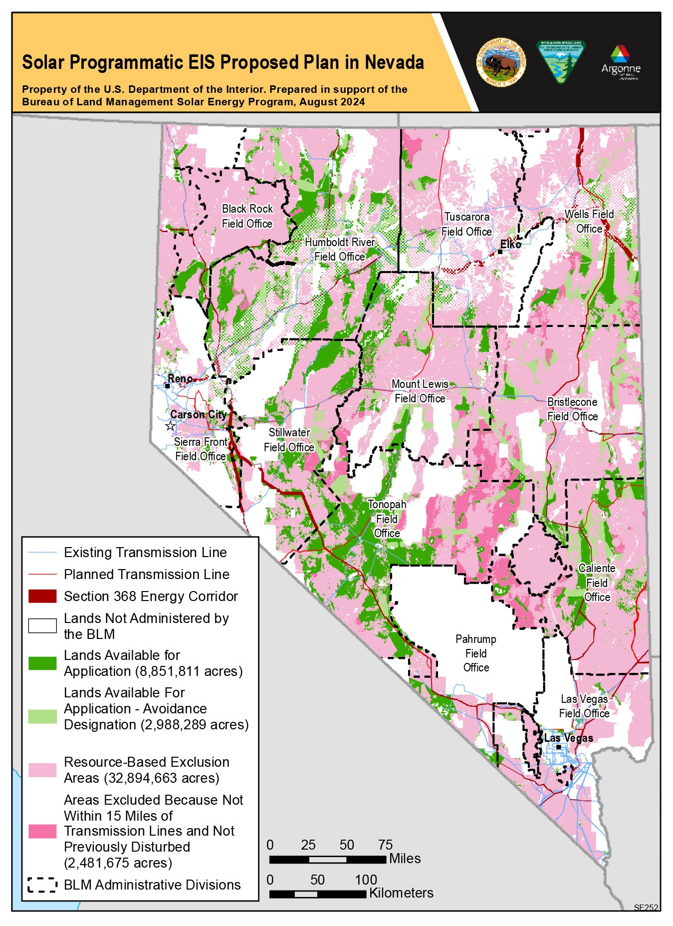
Understandably, Basin and Range Watch was heavily involved in public scrutiny of the Western Solar Plan (see map above), a BLM-managed framework that provides solar energy contractors access to 32 million acres of public land across eleven western states. Although one plan goal is to direct project permitting to areas near transmission infrastructure or on previously disturbed lands, many environmental and conservation groups, including Basin and Range Watch, argue that the BLM’s Final Programmatic Environmental Impact Statement has made forty-five times as much land available as its earlier stated goal of 700,00 acres, with no cap on development.[13]
There is no renewable energy industry. There is just the energy industry.
–Chris Clarke, 90 Miles from Needles podcast
According to the Toiyabe Sierra Club Chapter, Nevada alone could sacrifice nearly 12 million acres, which is a quarter of BLM-managed land in the state and more than double any other western state included in the plan. Several national conservation groups filed formal objections, citing the failure to protect wildlife migration corridors, habitat connectivity, and previously excluded lands, and noted that the preferred alternative, which restricted solar development to 8.4 million acres on disturbed or degraded lands, was ignored. Many conservationists, including Basin and Range Watch and Chris Clarke, host of the desert advocacy podcast 90 Miles from Needles, conclude that multinational solar developers and investor-owned utilities drove the BLM’s decision-making. Clarke states in his June 26, 2024 episode that “there is no renewable energy industry. There is just the energy industry,” and that the plan, as finalized, will contribute greatly to solar sprawl.[14]
The town of Beatty had several solar PV project applications that, if built, would collectively cover 35,000 acres of public land north and south of town. These included the 800 MW, 6,515-acre Beatty Energy Center, which would be visible from the Rhyolite ghost townsite and extend to the northeast entrance of Death Valley National Park; the massive 10,000-acre Sawtooth Solar Project to the north in Sarcobatus Flat; and the smaller Bonnie Clare Solar Project. In June 2022, after strong opposition from the Beatty community with support from the Nye County Board of Commissioners, the BLM downgraded all three projects to “low priority” permitting status. Accordingly, the Beatty Energy Center was withdrawn by its developer in August 2022.
According to the Amargosa Conservancy, at least twenty-five utility-scale solar applications have been submitted across 220,000 acres in the Amargosa River Watershed designated for solar development under the Western Solar plan. Several are moving forward, including NextEra Energy’s 1.6 GW, 10,000-acre Rock Valley Energy Center and NV Energy’s 7,226-acre Amargosa North and South solar projects, which NV Energy leased for a staggering $81.85 million at a 2023 BLM auction.[15] Rock Valley could be located only sixteen miles north of Ash Meadows National Wildlife Refuge at the Lathrop Wells junction of US 95 and SR 373. Another pending application, the 10,122-acre, 1.2 GW Tidewater Solar Farm, LLC, if built, will border the refuge on two sides. Many community, county, and state leaders support establishing the 185,000-acre Ash Meadows National Conservation Area, a proposal that grew out of local resistance to the lithium mining plans of Canadian firm Rover Critical Minerals. That resistance succeeded: Rover abandoned its leases in 2025. However, whether the Trump administration’s Department of the Interior will follow through on permanent protection remains uncertain.
Protecting groundwater is a top priority for Amargosa Valley residents, not only for their own use but also for the Ash Meadows National Wildlife Refuge. This concern was central to the community’s effort to prevent Rover from proceeding with exploratory drilling in the Amargosa River Watershed, a move that hydrological experts say could permanently disrupt the interconnected groundwater system. At a packed June 2024 Amargosa Valley town hall meeting, where residents voiced strong criticism of Rover’s exploratory drilling near Ash Meadows, attendees reported that their wells, once drawing water at 90 feet, had to be re-drilled to 200 to 300 feet at a cost of up to $30,000 because they had gone dry in recent years. The valley’s largest current water user is a 2,000-acre commercial dairy, which is closing and transitioning to a PV solar facility. The dairy’s water rights are included in the sale. The solar farm will use far less water than the dairy and will no longer emit livestock-produced methane, a greenhouse gas that contributes to global warming. However, it will still require ample water during construction and operation.
For residents of the Amargosa Valley and Beatty, the primary concern is the cumulative effect of groundwater pumping across the watershed. Erika Gerling, Beatty’s Town Hall Advisory Board Chair, whose municipality shares the same water supply, said at the same town hall meeting that utility-scale solar is expected to cover more than 23,675 acres northeast of the Amargosa Valley, extending into Beatty and farther north. To address these concerns, the USGS is developing a groundwater framework, the Southern Amargosa eMbedded Model, as a follow-on to the DVRFS. Solar developers may need to contend with limitations on groundwater use for future large-scale PV projects in the area.
Land is not a renewable resource.
–Laura Cunningham, co-founder, Basin and Range Watch
Moving gigawatts of solar-generated electricity over long distances requires new transmission infrastructure. For years, Basin and Range Watch has opposed NV Energy’s $4.2 billion Greenlink West 525-kV transmission line, now under construction. The line’s path, which runs from Las Vegas to the Reno area, will cut a swath through the last remaining intact wilderness in the Lower 48, including Las Vegas’s paleontological gem, the Tule Springs Fossil Beds National Monument, as well as other historic and archaeological artifacts and resources along the route. Greenlink West runs along the scenic US 95 public-land corridor through the southwestern part of the state. As it passes through Beatty, it will cross The Nature Conservancy’s Gary and Lajetta Atwood Preserve and be within three miles of Cunningham and Emmerich’s ranch, while conveying 4 GW of electricity over 472 miles. It should come as no surprise that Basin and Range Watch and Friends of Nevada Wilderness are actively suing the Department of the Interior over this transmission project.[16]
Scheduled to deliver power in May 2027, Greenlink West begins at the 531 MW natural gas Apex Generating Station, northeast of Las Vegas, and extends north to the massive 160-square-mile Tahoe Reno-Industrial Center (TRIC), an industrial park that is home to numerous existing and future hyperscale data centers, sprouting up between the towns of Sparks and Fernley. Masterminded by the colorful cowboy land developer and brothel owner Lance Gilman, TRIC is considered one of the fastest-growing data center regions globally and serves as a hub for warehousing, logistics, and fulfillment for Walmart, PetSmart, and others. The center is home to a 5.4 million-square-foot Tesla Gigafactory and data centers for Apple, Blockchains, Google, Microsoft, Switch, and soon Amazon.[17] It is estimated that TRIC has accumulated 35 to 45 million square feet of built space since 2014, with an additional 13 million square feet under construction as of 2025.[18] Five on-site natural-gas power plants currently supply 900 MW of electricity to these enterprises, with additional plants planned.
Although the TRIC website highlights the location’s “high solar potential” as a “green energy alternative,” only one of its high-profile tech tenants has rooftop solar: the Tesla Gigafactory, which showcases a rendering of a fully solar-roofed facility on its website home page but, to date, features working solar on half of its existing building.[19] Apple, which boasts that it runs all worldwide operations with 100 percent renewable energy, acquired the 61 MW, 180-acre Turquoise Solar Project less than a mile away to power its 400,000-square-foot, $1 billion TRIC data center complex. But it lacks any rooftop solar, and it is unclear whether it will be installed in the future. Apple has three additional solar projects in the region, delivering 270 MW to its TRIC facility, including a 19.9-MW PV solar farm near Yerington, Nevada, 71 miles to the south.[20] That said, the astounding amount of energy these data centers require cannot be met solely by covering their tech center rooftops with solar, but doing so could help reduce their rising operational energy needs.
According to a 2026 report by the Desert Research Institute (DRI), 70 data centers statewide consumed 22 percent of Nevada’s electricity in 2024. By 2033, new data centers are expected to increase by 35 percent, requiring 25,590 GWh of electricity—about 56 percent of what the state currently generates.[21] The state’s current peak electrical demand is approximately 9,000 MW.
Several substations are under construction along the Greenlink West route, including a new 230-kV complex south of Beatty, within the viewshed of the Amargosa Valley’s Big Dune Recreation Area, now called Sagebrush. The new Esmeralda substation, located about 125 miles north of Sagebrush in the remote Big Smoky Valley, south of Tonopah, is also under construction. This substation will connect the gargantuan Esmeralda 7 Solar Projects, currently in federal permitting limbo, which, combined, could erase up to 62,300 acres (about 100 square miles) of contiguous and undisturbed desert habitat to produce up to 6.2 GW of electricity.[22] The end of the line is the Comstock Meadows Substation, which directly serves the TRIC and is currently under expansion.
Rather than stating how many homes Greenlink West will electrify, NV Energy—and journalists who report on renewable energy—should instead state, “Greenlink West’s clean energy will power six hyperscale 1,000 MW datacenters.”
NV Energy boasts that Greenlink West’s “clean” energy will power at least 4.8 million homes.[23] But this is misleading because much of the electricity transported south to north will power the TRIC data center build-out in the Tahoe-Reno area or new data centers in Las Vegas. Rather than stating how many homes Greenlink West will electrify, NV Energy—and journalists who report on renewable energy—should instead state, “Greenlink West’s clean energy will power six hyperscale 1,000 MW datacenters.”[24] After all, PV-equipped home rooftops in sunbaked Nevada can easily provide all the electricity required to comfortably heat and cool a home, plus charge an EV.
Herein lies the utility-scale solar “dirty” energy secret: when NV Energy rolled out its new transmission infrastructure proposal to the public in July 2021, its Plan of Development stated, “Development of the Greenlink West Transmission Project facilitates access to renewable energy zones and is necessary to accommodate decommissioning of conventional fossil fuel generation resources.” It described Greenlink as crucial to meeting the state’s 2019 Renewable Energy Standard, which requires 50 percent of NV Energy’s electricity to come from renewables by 2030. [25] NV Energy is now backtracking on this promise with a revised May 2026 Integrated Resource Plan that asks the state’s regulatory Public Utilities Commission of Nevada to allow it to build 1.2 GW of new natural gas-fired power plants, in addition to those already operational, to meet the data center build-out’s huge energy demand. Any federally regulated energy company is legally required to provide service to any customer or business in good standing that requests service.
Future electricity demand may outpace Greenlink West’s transmission capacity before construction is even finished. In the meantime, Nevadans, like ratepayers nationwide, are subsidizing new generation and transmission infrastructure that powers and cools data centers through higher rates on their monthly electricity bills.[26] Notably, state-regulated investor-owned utilities do not profit from selling electricity; instead, utilities, on average, earn a 10 percent margin by “improving grid resilience” through capital investments such as the construction of new generation or distribution infrastructure, whose costs are passed on to customers—even if the new equipment becomes obsolete.[27]
The current White House has made clear it will not federally regulate the AI and data center industries, and it is unclear whether state Public Utility Commissions or lawmakers will do so. Companies running these operations are known to shop around across multiple markets to secure the most lucrative terms, and without regulation there is no guarantee that contracts will be honored if large-load customers, such as data centers, pull out or later go bankrupt, leaving ordinary ratepayers responsible for the huge debt incurred. Furthermore, the so-called clean energy powering these facilities tells only part of the story: much of the actual shortfall is being filled by fossil fuel plants, hastily approved and built, that will drive climate change for years to come.
Further, most data centers require extravagant amounts of water to evaporatively cool heat-generating computing systems and other operations.[28] DRI’s 2026 report states that data centers used 66 billion liters of water in 2023. DRI projects that twelve of the 70 data centers in Nevada will consume 11.9 billion liters of water by 2033, equivalent to the drinking water for 24.1 million adults annually. Notably, TRIC built a water treatment facility to collect and recycle on-site wastewater and partnered with the community-owned Truckee Meadows Water Authority to build a 16-mile pipeline to deliver additional treated effluent for tenant use, starting in 2026.[29] But, as a general rule, data centers require potable water—not treated wastewater—for most operations, including evaporative cooling. All of which will come from local groundwater or from the Truckee River, a regionally strained water source.
Public anxiety over the risk of groundwater depletion from data center buildouts has grown as quickly as data centers have proliferated. The Nye County Water District Governing Board approved an emergency order in May 2026, requesting that the Nye County Commission place a moratorium on data centers in the Pahrump Valley due to water concerns. Angry Tucson residents convinced their city council in August 2025 to unanimously block construction of Amazon Web Services’ planned $3.6 billion Project Blue data center complexes due to water and energy concerns. The City of Tucson is now establishing regulations and standards for large-scale data centers within its city limits.
Without its nameplate customer, the developer, Beale Infrastructure, is proceeding to build one of the planned data centers on spec on 290 acres in unincorporated Pima County, just outside the city limits. The project remains in hot water locally; Beale’s local contractor was found siphoning City of Tucson water for construction dust control in early May 2026 after the company was denied water access by city officials. Further, Beale claims that its “air-cooled” facility will use minimal—a claim that rings hollow since the State of Arizona approved the company’s request for permits to drill wells capable of pumping up to 31 million gallons of water annually in the spring of 2026.[30] The No Desert Data Center Coalition, a local activist group that formed in 2025 to fight Project Blue, whose slogan is “Not One Drop,” continues to monitor Beale’s secretive business dealings, stating that data center developers have “no intention to actively regenerate and revitalize the land, or reconcile the harmful legacy of extractive industries in the Sonoran Desert.”[31] Understandably, a May 2026 Gallup poll shows that seven out of ten Americans oppose the construction of data centers in their communities, with nearly half strongly opposed.
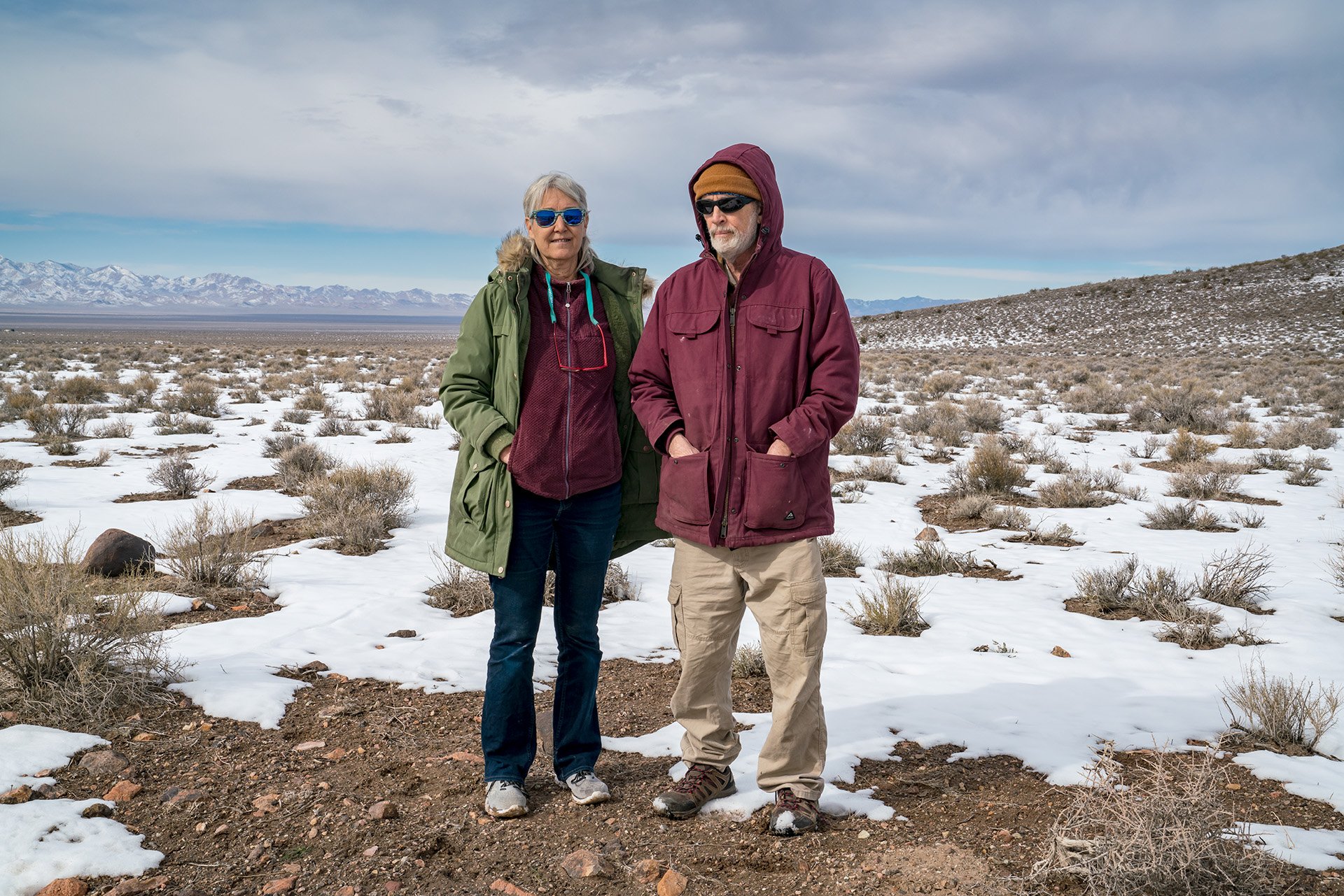
Basin and Range Watch co-founders Laura Cunningham and Kevin Emmerich were photographed at Sarcobatus Flat in January 2023. The federally managed basin faces competing extraction pressures: a proposed 10,000-acre solar farm and overlapping lithium mining claims on the same public land.
At Sarcobatus Flat, Basin and Range Watch is monitoring an application for a troubling “un-gridded” data center northeast of U.S. Route 95 at Scotty’s Junction, about 30 miles north of Beatty. The flat is a north-south-trending, undeveloped 40,000-acre basin and Joshua tree bajada, named for the alkali-loving greasewood (Sarcobatus vermiculatus) that thrives in the Southwest’s desert saline soils. Bounded to the west by Death Valley National Park’s Grapevine Mountains and to the east by the restricted Nellis Air Force Range, Sarcobatus Flat marks where the northern Mojave quietly transitions to the Great Basin. This lonely stretch of highway is one of my favorites, with its vast, introspective, moody vistas.
Until recently, Sarcobatus Flat was a wide-open desert, most of which is federally owned. An exception is a 2,800-acre parcel with water rights at Scotty’s Junction, which was transferred to the Timbisha Shoshone under the Timbisha Shoshone Homeland Act of 2000, on which the Timbisha operate a small marijuana dispensary. Still, human habitation is sparse—the Shady Lady, a former legal brothel just south of the area, now serves as an off-the-beaten-path bed and breakfast. Although most of the early mining sites have faded back into the landscape, lithium exploration is underway on the vast white alluvial playa extending southwestward. A few years ago, solar developers were vying for the same public land already claimed for lithium mining.
In early 2026, Nye County commissioners granted preliminary approval for TeslaSolar, LLC (unaffiliated with Elon Musk’s company) to build a 244-MW, 800-acre solar installation with a battery backup northeast of the highway at the junction with battery backup, designed to power a data center 24/7 and transmit processed data via satellite. One commissioner recused himself from the vote due to his business affiliation with the company.[32] What makes this development unique is that the operation will not be tied to the electrical grid. Cunningham and Emmerich fear that this untethered data center, along with the lithium mine, will permanently transform Nevada’s outback into another sprawling industrial zone and set a disturbing precedent for others. Given the flat’s fenceline proximity to the infamous Nevada National Security Site, with its toxic legacy of long-lived manmade radioactive contaminants that will linger on the land and in the groundwater for thousands of years—24,000 years for the plutonium scattered in a nearby restricted area[33]—sacrificing more public land along this stunning wilderness corridor is heartbreaking.
The forthcoming final dispatch in this series examines the multi-decade, coordinated campaign by investor-owned utilities, backed by state utility commissions nationwide, to dismantle the distributed solar economy. Net metering, rooftop solar incentives, community solar programs, and virtual power plants are the tools that enable homeowners, renters, small businesses, and rural communities to generate electricity locally, near the point of use—rather than at massive, centralized solar farms that devour public lands in the Desert West. The dispatch will also examine sustainable models for large-scale solar that consider land use, ecological impacts, and the communities living alongside them, making the case that renewable energy and intact desert landscapes need not be mutually exclusive.
Did you enjoy reading this dispatch? Support us with your tax-deductible donation.
FOOTNOTES (click to open/close)
[1] EIA energy statistics for 2025 won’t be available until November 2026. U.S. Energy Information Administration, ‘Nevada State Energy Profile Overview,” U.S. Energy Information Administration, last updated May 21, 2026, accessed June 1, 2026, https://www.eia.gov/states/NV/overview.
[2] Author’s calculations based on Nevada utility-scale solar generation of 13,640 GWh and California utility-scale solar generation of 55,574 GWh in 2025, per U.S. Energy Information Administration, “Electricity Data Browser,” U.S. Energy Information Administration, accessed June 16, 2026, https://www.eia.gov/electricity/data/browser/, divided by estimated 2025 state populations of approximately 3.2 million (Nevada) and 39.5 million (California), per U.S. Census Bureau, “Nevada QuickFacts” and “California QuickFacts,” accessed June 16, 2026, https://www.census.gov/quickfacts/NV and https://www.census.gov/quickfacts/CA.
[3] Sammy Roth, “Solar Sprawl Is Tearing Up the Mojave Desert. Is There a Better Way?” Los Angeles Times, January 23, 2023.
[4] Dana Gentry, “Tech, Tariffs, and Trump Cloud NV Energy Effort to Reduce Carbon Footprint,” Nevada Current, April 30, 2025, https://nevadacurrent.com/2025/04/30/tech-tariffs-and-trump-cloud-nv-energy-effort-to-reduce-carbon-footprint/.
[5] As of December 2025, MGM powers 100 percent of its Las Vegas Strip properties’ daytime electricity demand with solar energy, with the addition of the 115 MW Escape Solar and Storage Project in Lincoln County, north of Mesquite, Nevada, to its solar energy portfolio. “MGM Resorts Powers Up to 100% of Daytime Las Vegas Strip Electricity with Solar,” press release, MGM Resorts International Newsroom, January 20, 2026, https://newsroom.mgmresorts.com/2026-19-01-Daytime-Electricity-Solar.
[6] U.S. Bureau of Land Management, “Renewable Energy Generated on BLM-Managed Public Land Comes Online to Power Resorts in Las Vegas,” press release, June 29, 2021, https://www.blm.gov/press-release/renewable-energy-generated-blm-managed-public-land-comes-online-power-resorts-las.
[7] Adrian Slade, “Effects of Solar Arrays on Southwestern Desert Thermal Landscapes: Consequences for Terrestrial Ectotherms” (MS thesis, Central Washington University, 2023), https://digitalcommons.cwu.edu/etd/1909.
[8] Primergy Solar and Quinbrook Infrastructure Partners, “Historic Gemini Solar + Energy Storage Project Reaches Commercial Operations in Nevada,” press release, Business Wire, July 18, 2024, https://www.businesswire.com/news/home/20240718110673/en/Historic-Gemini-Solar-Energy-Storage-Project-Reaches-Commercial-Operations-in-Nevada/.
[9] Roth, “Solar sprawl is tearing up the Mojave Desert. Is there a better way?” Los Angeles Times.
[10] See Claire Karban and Alice E. Karl “Solar-Wildlife Webinar Series #3: Discussing the Intersections Between Desert Tortoises & Solar Development,” webinar moderated by Josh Ennen, Renewable Energy Wildlife Institute, July 24, 2025, https://rewi.org/webinars/intersections-between-desert-tortoises-solar-development/
[11] Alice E. Karl et al., “Exile to Entry: An Update on the Gemini Solar Project” (abstract, Desert Tortoise Council 2026 Symposium, February 19, 2026), https://deserttortoise.org/wp-content/uploads/Abstracts-for-2026-symposium19Febweb-correct.pdf.
[12] Ruth Nolan, Shannon Salter, and Claire Vaye Watkins, “Where Is the People’s Solar?” The Nevada Independent, January 21, 2022, https://thenevadaindependent.com/article/where-is-the-peoples-solar.
[13] Sierra Club Range of Light Group, “BLM Western Solar Plan PEIS,” Sierra Club Toiyabe Chapter, November 29, 2024, accessed June 1, 2026, https://www.sierraclub.org/toiyabe/range-light/blog/2024/11/blm-western-solar-plan-peis.
[14] Chris Clarke, “Desert Protection versus Climate Capitalism: Can We Have Both?” 90 Miles from Needles: The Desert Protection Podcast, season 3, episode 20, June 26, 2024, https://www.90milesfromneedles.com/s3e20-desert-protection-versus-climate-capitalism-can-we-have-both/.
[15] NV Energy’s tract lease is within the 2012 Amargosa Energy Zone, which locals and the Amargosa Conservancy support for utility-scale PV solar development.
[16] Friends of Nevada Wilderness et al. v. United States Bureau of Land Management et al., No. 2:25-cv-00929 (D. Nev., filed May 28, 2025).
[17] If the eventual buildout as planned is achieved, the Gigafactory could eventually reach thirteen million square feet.
[18] James Temple, “The Data Center Boom in the Desert,” MIT Technology Review, May 20, 2025, https://www.technologyreview.com/2025/05/20/1116287/ai-data-centers-nevada-water-reno-computing-environmental-impact/.
[19] Estimate based on 2026 Google Map land satellite image of the Nevada Tesla Gigacenter’s rooftop.
[20] “Apple’s $60 miliion solar farm near Reno now operational,” Northern Nevada Business Weekly, March 19, 2021, https://www.nnbw.com/news/2021/mar/19/apples-60-million-solar-farm-near-reno-now-operati/.
[21] Sean McKenna and Erik Henzl, “Data Centers in Nevada,” ArcGIS StoryMaps, Desert Research Institute, April 29, 2026, accessed June 1, 2026, https://storymaps.arcgis.com/stories/5fe420f0d5c948c3a07715ad1cfe73ba.
[22] Although the Department of Interior canceled the Esmeralda 7 Solar Projects in October 2025, each of the seven solar projects will be reviewed separately, if resubmitted.
[23] Not so clean: When operational, Greenlink West will distribute electricity generated by natural gas-powered power plants in Apex as well as solar generated power.
[24] According to a May 2024 EPRI (Electric Power Research Institute) report cited in a 2025 congressional report, a single “hyperscale” AI data center can consume up to 1,000 MWh of electricity, enough to power about 800,000 homes. Jordan Aljbour, Tom Wilson, and Poorvi Patel, “Powering Intelligence: Analyzing Artificial Intelligence and Data Center Energy Consumption,” white paper no. 3002028905 (Palo Alto, CA: Electric Power Research Institute, May 2024).
[25] Nevada Power Company and Sierra Pacific Power Company d/b/a NV Energy, “Greenlink West Transmission Project: Plan of Development,” submitted to the U.S. Bureau of Land Management, July 30, 2021, 3, https://www.blm.gov/sites/blm.gov/files/docs/2021-09/NVEGL_Greenlink%20West_POD_Rev1_20210730%20%281%29.pdf.
[26] Dana Gentry, “NV Energy betting the house on data centers,” Nevada Current, June 3, 2026, https://nevadacurrent.com/2026/06/03/nv-energy-betting-the-house-on-data-centers.
[27] David Schlissel, “How Wall Street Is Shifting Electric Utilities toward Consolidation and Profit,” The Conversation, June 16, 2026, https://theconversation.com/how-wall-street-is-shifting-electric-utilities-toward-consolidation-and-profit-284147.
[28] Google’s Storey County Nevada facility is air-cooled, requiring far less water than those liquid-cooled but requires ten percent more electricity to operate. In 2021, the company pledged to replenish 120 percent more water than it consumes by 2030. https://blog.google/company-news/outreach-and-initiatives/sustainability/replenishing-water/.
[29] Temple, “The Data Center Boom in the Desert,” MIT Technology Review.
[30] David Gerard, “Tucson Project Blue: Data Centres Lie about Water Again,” Pivot to AI, May 19, 2026, https://pivot-to-ai.com/2026/05/19/tucson-project-blue-data-centres-lie-about-water-again/.
[31] Paul Ingram, “Project Blue’s 2 New Tucson Wells Could Draw up to 31 Million Gallons of Water Annually,” Tucson Sentinel, May 18, 2026, https://www.tucsonsentinel.com/local/report/051826_project_blue_wells/project-blues-2-new-tucson-wells-could-draw-up-31-million-gallons-water-annually/.
[32] Robin Hebrock, “Sarcobatus Solar Secures Special Use Permit from Nye County,” Pahrump Valley Times, January 28, 2026, https://pvtimes.com/news/sarcobatus-solar-secures-special-use-permit-from-nye-county-175201/.
[33] On May 15, 1963, the U.S. military deliberately detonated a non-nuclear device containing plutonium and depleted uranium on the Nellis Air Force Range as part of the Double Tracks safety experiment, designed to measure how radioactive materials disperse in the environment. Between 2.2 and 3.5 pounds of plutonium were scattered across the site at the northwestern edge of Stonewall Flat’s alluvial fan below the Cactus Mountains — a drainage that empties into Sarcobatus Flat.